Residential Surveying Services
BFA offers a variety of residential surveys to meet your needs. With over 55 years of surveying experience, our team is well-versed in the rules and regulations of local and state jurisdictions, and we are committed to providing high quality, accurate residential surveys in a timely, cost conscience manner.

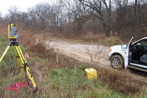
Boundary Survey
A boundary or property survey determines the location of property lines and the monuments that mark the property corners of a parcel of land as described in a deed. The land surveyor performing a boundary survey will examine the deed for the property and possibly neighboring deeds.
Deeds are normally located in the county courthouse. The land surveyor may also talk with the owner and/or neighbors to get information they have regarding the location of a boundary line. The field work begins by locating all available monuments.
A full boundary survey is also commonly known as a “mortgage survey” or “loan survey” because it is the most common residential survey and meets the requirements for most mortgage companies.
When is a boundary survey necessary?
- A boundary survey can determine if there are any easements for utilities (water, sewer, electric, gas, etc.) on your property.
- A boundary survey identifies any encroachments (driveways, fences, buildings, etc.) on the property or crossing any of your boundary lines.
- A boundary survey and drawing provide you the exact property line measurements and locations of all structures (houses, barns, etc.), fences, or driveways related to those property boundary lines.
- Completing a boundary survey can provide markings along your property lines which allow you to put up a fence on your property line in the correct location so that you don’t encroach on another property.
- A boundary survey is the first step in being able to subdivide your property to divide it among family members.
- A boundary survey should be done to make sure the building you’re constructing is properly placed on the lot, and not encroaching on any easement lines.
Often to settle property disputes or clarify boundaries prior to building, clients may only need a property line staking or a survey to mark property corners.
Feel free to contact our Survey Department and they will assist you in selecting the correct survey for your needs.
A Boundary Survey is used to establish the true boundaries of a given property.
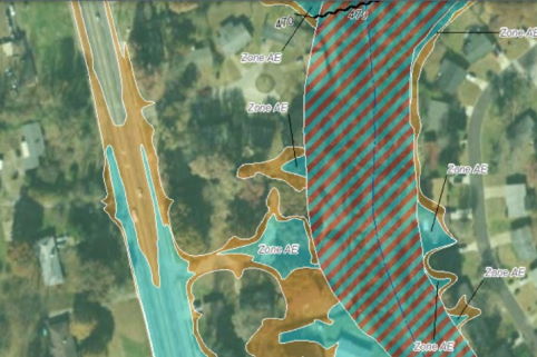
FEMA Elevation Certification
FEMA Elevation Certification is a useful tool for property owners living in (or near) a delineated flood plain. The government regularly identifies and maps areas of land that are susceptible to flooding, based on previous history. These maps are periodically revised as flood patterns are identified and refined, which means a parcel of land that was not zoned for flooding 10 years ago may be in a flood zone now, and vice versa. This is why elevation certification must be updated occasionally.
BFA has the experience to provide accurate data for FEMA Elevation Certification for your residential property.
How FEMA Elevation Certification Works
FEMA requires flood insurance to be purchased for any land on which flooding is expected to occur within the next 100 years (known as a Special Flood Hazard Area – SFHA). The more likely flooding is to occur, the higher the premiums will be. To determine where your residential or property lies in relation to flood-prone areas, a Professional Land Surveyor can perform field analysis, determining the elevation of the land and any buildings on it. The surveyor will then pinpoint the location of the property on a Flood Insurance Rate Map (FIRM) and complete a FEMA Elevation Certificate, which is used to determine how much flood insurance will be required (if any).
When is FEMA Elevation Certification Necessary?
- If you make substantial changes to your building in a high-risk area—for example, you make an addition to your home or convert the garage to living space—you likely need a new Elevation Certificate to reflect the new building characteristics and Lowest Floor Elevation.
- If there is no Elevation Certificate on file because the FIRM maps were not drawn or in force the last time the property was purchased or sold.
- If the FIRM maps have been recently updated to include your property (in other words, your property is now in a flood plain when it previously was not).
- If you suspect that your property’s flood rating has changed, and you want to request a Letter of Map Amendment (LOMA) to change its status.
LOMA – Letter of Map Amendment
If an Elevation Certificate shows that your property is above the Base Flood Elevation at all points, you still have the requirement to obtain flood insurance. Only after the submission and approval of a Letter of Map Amendment (LOMA) can the Flood Map be amended and the Federal mandate for the purchase of flood insurance be removed.
FEMA Elevation Certification can be a useful tool for property owners living in (or near) a delineated flood plain.
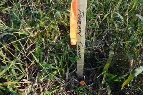
Property Line Location
When you need to visualize the actual boundary line of your property, BFA offers thorough property line staking services. This service is helpful and necessary if you need clarity on where to build a structure near the edge of your property, and it can prevent expensive encroachment issues with your neighbors later on. It can also help to clarify vague or inaccurate legal descriptions and resolve disputes with neighbors regarding boundary location.
When is property line staking needed?
- If you are planning to place a structure or perform landscaping near the edge of your property.
- A boundary survey identifies any encroachments (driveways, fences, buildings, etc.) on the property or crossing any of your boundary lines.
- A boundary survey and drawing provide you with the exact property line measurements and locations of all structures (houses, barns, etc.), fences, or driveways related to those property boundary lines.
- Completing a boundary survey can provide markings along your property lines which allow you to put up a fence on your property line in the correct location so that you don’t encroach on another property.
- A boundary survey is the first step in being able to subdivide your property to divide it among family members.
- A boundary survey should be done to make sure the building you’re constructing is properly placed on the lot and not encroaching on any easement lines.
Property Line Location is the method used to locate property lines between adjacent land owners.
Farm Survey
The term “farm survey” may have more than one meaning, depending on the circumstances of the job. Farm surveys are often used to locate or determine existing boundaries of land, or to legally separate building sites from the rest of the land.
One common use of a farm survey is to locate the existing boundaries and determine the area of land which has been subdivided. In other cases, a farm survey is used to divide larger sections into smaller ones. In both cases, it is common that the survey will require the finding or re-establishment of several, if not all, of the section and quarter-section corners in that particular section in order to properly determine and or further subdivide the areas of land in question.
Why Would I Need a Farm Survey?
Surveyors use legal descriptions to create a visual outline of your property boundaries, also measuring the size or acreage. Often with rural land, tradition, and history dominate facts. Boundaries can become historical rather than legal. For example, your great-great-grandfather may have erected a fence close to the property line but not exactly on it. Over time, the fence represents the property boundary for both you and your neighbors. A survey will either debunk or confirm those longstanding beliefs. Even if you’ve existed peacefully with neighboring landowners for years and had no property line issues, a potential buyer may find themselves with different neighbors who may not be as easygoing. A survey will avoid future conflicts and legal entanglements.
Farm surveys are typically used to locate or determine existing boundaries of land, or are used to legally separate building sites from the rest of the land.